
 Español
 Euskera
 Français
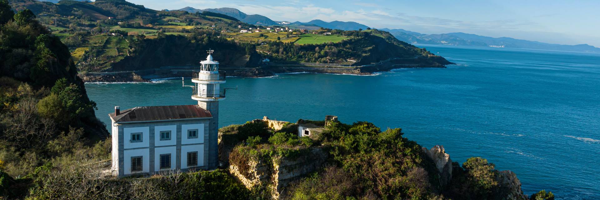
Natural environment
Getaria is located in the Coastal Range, in an area comprising tertiary materials, forming spectacular eroded hillsides. These eroded layers, when they enter into the sea, create a geological phenomenon called flysch. Its privileged location is a palette in which all palettes, with a predominance of blue and green are mixed.
From any of the four rural districts, San Prudencio, Askizu, Eitzaga or Meaga, natural spectacle, with the sea as a backdrop, offers a of fields covered by vineyards, whose fruit will be transformed into txakolí.
Between these fields runs the Camino de Santiago known as "the coast" which coming from Zarautz and through the town passes by the medieval hermitage of San Prudencio and reaches Askizu, an idyllic balcony over the Bay of Biscay where is the church of San Martin de Tours, patron of pilgrims and walkers.
In turn, these neighborhoods give the possibility of different routes to know a little further and discover the environment of Getaria. (There are plans at the tourist office).
LONG ROUTES
GR121: Talaia
This section of the GR trail, which runs between Hondarribia and Saturraran beach in Mutriku, crosses the old watchtowers of the whalers, hence the name of the route. This path, which faces the sea, crosses the Jaizkibel-Ulia ZEC, the Iñurritza Biotope, the Garate-Santa Bárbara ZEC and the Basque Coast Geopark, as well as several beaches, coves, forts, villages and neighbourhoods. In short, it offers an unbeatable opportunity to get to know the nature and culture of Gipuzkoa.
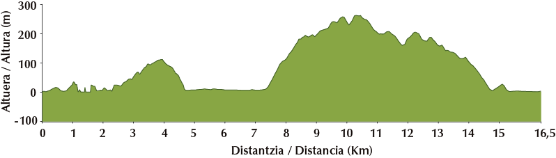
Stage 4: Orio - Zumaia
Technical data:
Distance: 16.5 km
Minimum elevation: 1 m
Maximum elevation: 263 m
Total ascent: 455 m
Total descent: 455 m
Estimated time: 5 h 25'.
SMALL ROUTES
PR-Gi 202: The Txakoli route
This circular route connects the coastal towns of Zumaia, Getaria and Zarautz with inland districts and villages, such as Urdaneta and Aizarnazabal. We can choose any of these towns as the starting point for our route and follow the direction we wish. We will walk through meadows, woods and small vineyards that bear witness to the txakolinera tradition of the region. Inland, we will gain altitude, passing through beautiful neighbourhoods such as Elkano, Urdaneta, Saitz, Zubialde and Oikia. The path will also take us to the banks of the river Urola.
Technical Data:
Distance: 24.7 km
Minimum elevation: 6 m
Maximum elevation: 333 m
Total ascent: 891 m
Total descent: 920 m
Estimated time: 8h 15'.

TOURIST ROUTES
Atalaya de San Antón Family Route
From the port of Getaria, climb up Mount San Antón towards the lighthouse. The foundations of the now disappeared chapel of San Antón and the cylindrical tower of a watchtower are preserved next to it. From this point you can see the entire Basque coastline stretching between the Higer and Matxitxako capes. Another watchtower was historically located on the top of San Antón hill. The current building, popularly known as "Katxapo", dates from the 20th century. The panoramic view from this watchtower is also marvellous.
Technical Data:
Distance: 1.7 km
Minimum elevation: 14 m
Maximum elevation: 107 m
Total ascent: 93 m
Total descent: 93 m
Estimated time: 30'.
Coastal path - Circular route
This path links Getaria and Zarautz along a flat walk along the cliffs that runs parallel to the N-634 road. We will pass by the cliffs of the Altzako Harria headland. In this area, on a rocky promontory, the Lasuntalai watchtower was located, which has now disappeared. From this watchtower, the watchman would observe the presence of shoals of alburs or other species in the bay of Malkorbe.
If, before reaching Zarautz, we take the path that takes us to the Santa Cruz watchtower and from there to the hermitage of Santa Barbara, we will return to Getaria, following a beautiful circular route.
Coastal path
Route for families
Accessible route
Technical Data:
Distance: 1.7 km
Minimum elevation: 14 m
Maximum elevation: 107 m
Total ascent: 93 m
Total descent: 93 m
Estimated time: 30'.
Circular route
Route for families
Technical Data:
Distance: 10,6 km
Minimum elevation: 1 m
Maximum elevation: 177 m
Total ascent: 301 m
Total descent: 301 m
Estimated time: 3 h